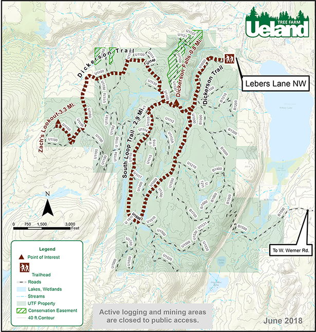
Trail Map
Welcome to Ueland Tree Farm
Ueland Tree Farm is open to the public for responsible, non-motorized recreation. Please remember we are an active tree farm and beware of logging and mining operations, truck traffic, wild animals, steep slopes, waterfalls, hunters and other visitors, among other potential hazards. Enjoy your visit! —Craig and Nicole Ueland

This map can be downloaded to a smartphone by scanning the QR Code below. The map is in PDF format so it can be viewed in Adobe Reader (adobe.com) AND it can be viewed using GPS positioning by installing “PDF MAPS” from the Apple Apps Store or the Google Play Store.
We are open to the following uses:
- Hiking
- Mountain Biking
- Horseback Riding
- Walking Dogs
- Jogging/Running
- Picking of berries and mushrooms
- Hunting (as regulated by the Department of Fish and Wildlife)
Restricted/prohibited uses:
Prohibited uses include—but are not limited to—the following:
- Motorized vehicles, including ATVs
- Camping or fires
- Fireworks
- Target Shooting
- Cutting or harvesting of timber or vegetation
- Any commercial, research or monitoring activities
As a private landowner, Ueland Tree Farm reserves its rights to restrict or limit entry to its property. Exceptions to the above rules must be approved in writing in advance.

Copyright © Ueland Tree Farm 2004. All rights reserved.